The function closestNode searches for the closest node in a
gGraph or a gData object to a given location. It is possible to
restrain the research to given values of a node attribute. For instance,
one can search the closest node on land to a given location.
Usage
closestNode(x, ...)

# S4 method for class 'gGraph'
closestNode(
  x,
  loc,
  method = "knn",
  zoneSize = 5,
  attr.name = NULL,
  attr.values = NULL
)

# S4 method for class 'gData'
closestNode(
  x,
  method = "knn",
  zoneSize = 5,
  attr.name = NULL,
  attr.values = NULL
)
Arguments
- x
a valid
gGraphorgDataobject. In the latter case, thegGraphto which thegDatais linked has to be in the current environment.- ...
further arguments passed to specific methods.
- loc
locations, specified as a list with two components indicating longitude and latitude of locations. Alternatively, this can be a
data.frameor a matrix with longitude and latitude in columns, in this order. Note thatlocator()can be used to specify the locations interactively.- method
the method to use for finding the closest node. The default is
"knn", which uses a fast FNN-based spatial index over unit-sphere Cartesian coordinates. The legacy"inArea"method is also available, but it is slower.- zoneSize
The initial size of the search area (in degrees). Only needs to be specified if
method = "inArea". The search zone will be expanded until at least 3 candidate nodes are found.- attr.name
the optional name of a node attribute. See details.
- attr.values
an optional vector giving values for
attr.name. See details.
Value
If x is a gGraph object: a vector of node names.
If x is a gData object: a gData object with matching nodes
stored in the @nodes.id slot. Note that previous content of
@nodes.id will be erased.
Details
This function is also used to match locations of a gData object with
nodes of the gGraph object to which it is linked.
When creating a gData object, if the gGraph.name argument is
provided, then locations are matched with the gGraph object
automatically, by an internal call to closestNode. Note, however, that
it is not possible to specify node attributes (attr.name and
attr.values) this way.
Examples
if (FALSE) { # \dontrun{
## interactive example ##
plot(worldgraph.10k, reset = TRUE)

## zooming in
geo.zoomin(list(x = c(-6, 38), y = c(35, 73)))
title("Europe")

## click some locations
myNodes <- closestNode(worldgraph.10k, locator(), attr.name = "habitat", attr.value = "land")
myNodes

## here are the closestNodes
points(getCoords(worldgraph.10k)[myNodes, , drop = FALSE], col = "red")
} # }

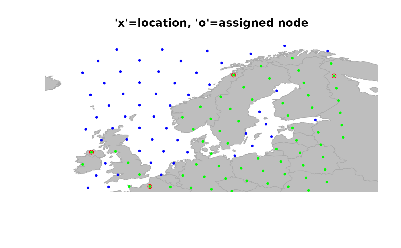
## example with a gData object ##
myLoc <- list(x = c(3, -8, 11, 28), y = c(50, 57, 71, 67)) # some locations
obj <- new("gData", coords = myLoc) # new gData object
obj
#>
#> === gData object ===
#>
#> @coords: spatial coordinates of 4 nodes
#>   lon lat
#> 1   3  50
#> 2  -8  57
#> 3  11  71
#> ...
#>
#> @nodes.id: 0 nodes identifiers
#> character(0)
#>
#> @data: data
#> NULL
#> ...
#>
#> Associated gGraph:

obj@gGraph.name <- "worldgraph.10k" # this could be done when creating obj
obj <- closestNode(obj, attr.name = "habitat", attr.value = "land")

## plot the result (original location -> assigned node)
plot(obj, type = "both", reset = TRUE)
#> Spherical geometry (s2) switched off
#> Spherical geometry (s2) switched on
title("'x'=location, 'o'=assigned node")